Glacier velocity
Background
Velocity measurements of glaciers can be determined by from repeat optical or radar image. It is possible to map glacier velocity sub-seasonally, and more accurately than earlier due to the higher spatial and temporal resolution of Sentinel-1 and Sentinel-2 satellite images (Kääb et al., 2016). In the Copernicus Glacier Service we used both Sentinel-1 and Sentinel-2 imagery to derive velocity maps. See description in the Copernicus Glacier Service project report for an overview (Andreassen et al., 2021).
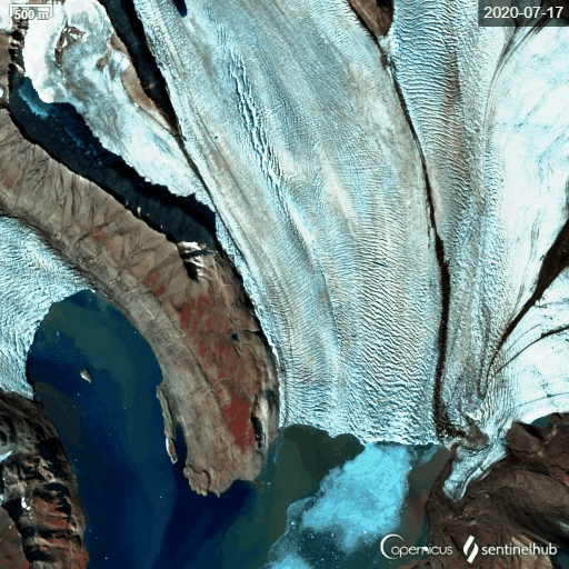
Timelapse Sentinel-2 imagery of Osbornebreen, Svalbard, in the period 17 July to 25 August 2020, Svalbard, showing rapid glacier flow.
Data for glaciers in mainland Norway
NVE has mapped surface velocity using optical imagery from Sentinel-2 for glaciers in Norway (Nagy and Andreassen, 2019). Sentinel-2A and Sentinel-2B imagery were used for establishing pairs for feature tracking. Resulting displacement fields were manually filtered taking into account expected magnitude and direction of movement. The glacier velocity dataset v2.1 gives velocity data for glaciers in mainland Norway for 2015-2018 and refers to Nagy and Andreassen (2019). The glacier velocity dataset v1.0 gives velocity data for Nigardsbreen, Tunsbergdalsbreen, Engabreen and Rembesdalskåka and refers to Nagy et al. (2019).
Download velocity data as a zipped file:
NVE 2019. Glacier velocity data. version 2.1. Copernicus Glacier Service/Copernicus bretjeneste. Norwegian Water Resources and Energy Directorate, Oslo, Norway.
NVE 2019. Glacier velocity data. version 1.0. Copernicus Glacier Service/Copernicus bretjeneste. Norwegian Water Resources and Energy Directorate, Oslo, Norway.
Data for glaciers on Svalbard
The University of Oslo has derived Svalbard-wide winter glacier velocities that were derived from Sentinel-1 images once every winter using offset tracking procedures programmed in the Gamma Remote Sensing software (Schellenberger et al. 2016). The velocities are derived from 2 pairs of images with 12-day intervals. The Svalbard-wide Sentinel-1 velocity data can be used for detecting surges, to study glacier dynamics, to assess ice discharges etc.
Download velocity maps as zipped file (106 MB):
Kääb A. 2019. Svalbard glacier velocities from Sentinel-1 offset tracking. University of Oslo and Norwegian Copernicus Glacier service.
NPI has mapped surface velocity from feature-tracking on pairs of Sentinel-2 images for selected regions and time periods using the ImGRAFT toolbox. The main purpose is to study changes of dynamically active (or surging) glaciers, as well as determining ice discharge to the ocean for all Svalbard glaciers on an annual basis. Averagedice glacier velocities for calving fronts will be published as a part of annual monitoring products of calving front change, ice discharge and frontal ablation (sum of melting and calving).
SenDiT toolbox
SenDiT (Sentinel-2 Displacement Toolbox) is a semi-automatic, open-source, flexible processing toolbox for retrieval of displacement maps with application to obtaining glacier surface velocities. SenDiT combines the download, pre-processing, feature tracking, and postprocessing of highest resolution Sentinel-2A and Sentinel-2B satellite images into a semi-automatic toolbox, leaving a user with a set of rasterized and georeferenced glacier flow magnitude and direction maps for further analyses. The solution is freely available and is tailored so that non-glaciologists and people with limited GIS knowledge can also benefit from it. If you use the toolbox for research or other purposes, please cite Nagy et al. (2019) in any publications. Please refer to License.txt file for full reference and license details. To start with the toolbox, please follow instructions in the 00_readme.txt file. SenDiT is developed by Teodor Nagy. Contact teonagy94 'at' gmail.com with any questions on the tool functionality.
Current version: SenDiT_v1_3 2.zip (uploaded 8 April 2019)
Previous version: SenDiT v1_3.zip (uploaded 6 march 2019)
References
Andreassen, L.M. (ed.), G. Moholdt, A. Kääb, A. Messerli, T. Nagy and S.H. Winsvold. 2021. Monitoring glaciers in mainland Norway and Svalbard using Sentinel. NVE Rapport 3-2021, 94 p.
Kääb, A., S.H. Winsvold, B. Altena, C. Nuth, T. Nagler and J. Wuite. 2016. Glacier Remote Sensing Using Sentinel-2. Part I: Radiometric and Geometric Performance, and Application to Ice Velocity. Remote Sensing, 8(7), 598. (pdf)
Nagy, T. and L.M. Andreassen. 2019. Glacier surface velocity mapping with Sentinel-2 imagery in Norway. NVE Rapport 37-2019, 35 s.
Nagy, T., L.M. Andreassen, R.A. Duller and P.J. Gonzalez. 2019. SenDiT: A Sentinel-2 Displacement Toolbox with application to glacier surface velocities. Remote Sensing, 11, 1151. (pdf)
Schellenberger, T., W. Van Wychen, L. Copland, A. Kaab and L. Gray. 2016. An Inter-Comparison of Techniques for Determining Velocities of Maritime Arctic Glaciers, Svalbard, Using Radarsat-2 Wide Fine Mode Data, Remote Sens-Basel, 8, https://doi.org/ARTN 78510.3390/rs8090785