Glacier lakes
Background
Glacier lakes are sensitive to climate change and can cause glacier-related hazards. Glacier lakes in mainland Norway have long posed a threat due to frequent outburst floods. A jøkulhlaup or Glacier Lake Outburst Flood (GLOF) is a sudden release of water from a glacier. The water source can be a glacier-dammed lake, a pro-glacial moraine-dammed lake or water stored within, under or on the glacier. Sentinel-2 imagery can be used to survey locations with previously registered GLOFs or detect new possible GLOF sites. Having an updated glacier lake outline dataset with identified glacier and moraine-dammed lakes can be used as the basis for investigation of future changes in lakes on a local or a national scale.

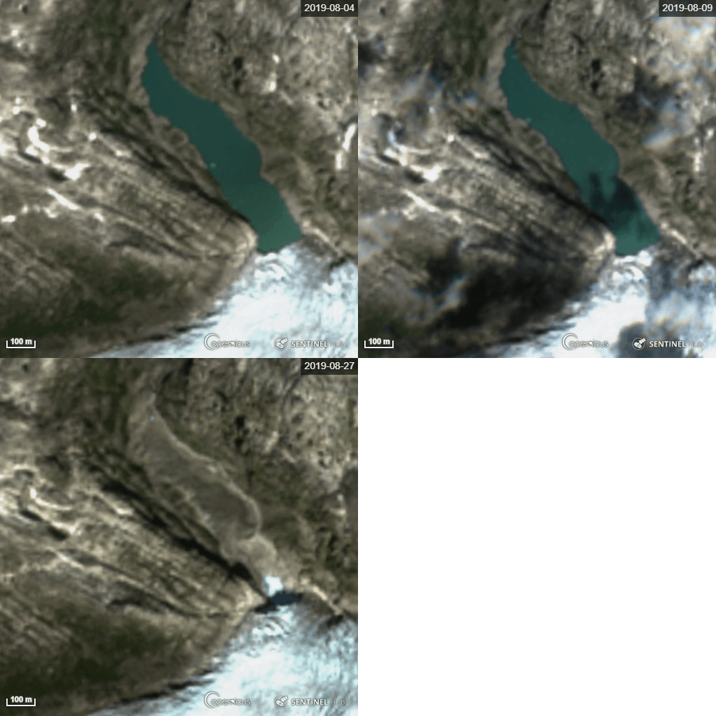
Sentinel-2 imagery showing the glacier dammed lake Demmevatnet in August 2019. The lake was emptied on August 24.
Data glacier lake outlines in mainland Norway
Two glacier lake outline datasets have been derived in the Copernicus Glacier Service project. They supplement previous outlines derived in the CryoClim project.
- Glacier lake outlines 2014: Mapping of the lake outlines was conducted using manual digitisation from Landsat imagery from 2014. Glacier lakes were defined as water bodies that either intersected or were within a distance of 50 m of the glacier outline of the previous inventory (1999-2006). Download data 2014
- Glacier lake outlines 2018: Mapping of the lake outlines was conducted using optical Sentinel-2 satellite imagery from 2018 by calculating the Normalized Differential Water Index (NDWI), applying a threshold and manually correcting outlines when necessary. The lakes were categorized according to the nature of the contact with the ice interface. Sites where lake emptying (jøkulhlaup) events had happened were identified. A NVE report describes the dataset (Nagy and Andreassen, 2019). Download data 2018
- Glacier lake outlines 2018/2019: Update of 2018 lake outlines using optical Sentinel-2 satellite imagery from 2018 and 2019 and manually correcting outlines when necessary and adding more glacier lakes. A NVE report describes the dataset (Andreassen et al., 2021). Download data 2018-2019
The lake inventory datasets are available for viewing at:
NVEs digital glacier BreAtlas at: https://gis3.nve.no/link/?link=breatlas
xGeo at: http://satellitt.xgeo.no/index.html?p=bre
Datasets for selected glacier regions or sites
-
Glacier Lake Outline Jostedalsbreen 2016-2021 for lakes around Jostedalsbreen ice cap mapped using Sentinel-2 and Plantescope. ( Pariyar, 2022).
- Glacier Lake Outline Norway 1961-2022 glacier lake outlines for selected locations in mainland Norway . Outlines digitised from available orthophotos from norgeibilder.no (Kjøllmoen & Andreassen, 2024, https://doi.org/10.58059/gpw7-0k22).
- Glacier Lake Outline Tystigbreen 2016-2022 bresjøomkrets av to bredemte sjøer ved Tystigbreen kartlagt med Sentinel-2 og Plantescope ( Aberhalden, Bly, Lappe, Andreassen, Rogozhina, 2024).
References
-Andreassen, L.M. (ed.), G. Moholdt, A. Kääb, A. Messerli, T. Nagy and S.H. Winsvold. 2021. Monitoring glaciers in mainland Norway and Svalbard using Sentinel. NVE Rapport 3-2021, 94 p. (GLO2014)
-Andreassen, L.M, T. Nagy , B. Kjøllmoen, J. Leigh. 2022. An inventory of Norway’s glaciers from 2018–19 Sentinel-2 data. Journal of Glaciology, https://doi.org/10.1017/jog.2022.20. (data 2018-2019)
-Nagy, T. and L. M. Andreassen. 2019. Glacier lake mapping with Sentinel-2 imagery in Norway. NVE Rapport 40-2019, 54 s.
Further information on glacier lakes
See more information on Jokulhlaups/GLOFs in Norway: https://www.nve.no/hydrology/glaciers/jokulhlaup-glof/
Overview of registered glacier lake outburst floods in mainland Norway. Information about registered events are given as well as photos of the affected glaciers.http://glacier.nve.no/viewer/GLOF/en/
